

A tropical depression or storm is likely to form soon in the central Atlantic, according to the latest advisory from the National Hurricane Center.
Invest 96L, located in the Central Atlantic east of the Leeward Islands, is forecast to become a tropical depression or storm during the next day or so.
Chances are dropping for the tropical development of Invest 97L, located east of North Carolina.
What’s an invest? We explain and break down the weather forecaster’s term
Forecasters also are tracking three tropical waves, including two in the Caribbean.
The next two names of the Atlantic hurricane season will be Emily and Franklin.
Here is the latest update from the NHC as of 8 a.m. July 31:
What’s out there and where are they?

- Invest 96L: Showers and thunderstorms continue in association with an area of low pressure located about 700 miles east-northeast of the northern Leeward Islands.
- Invest 97L: Showers and thunderstorms have changed little in association with an area of low pressure located offshore of the U.S. Mid-Atlantic coast.
- Tropical Wave 1: A tropical wave in the eastern Atlantic is located northwest of Cabo Verde. It’s moving west at 11 mph. Exact location: near 28W from 04N to 20N.
- Tropical Wave 2: A tropical wave is crossing the Lesser Antilles into the Caribbean Sea. It’s moving west at 11 mph.
- Tropical Wave 3: A tropical wave in is the Caribbean. It’s moving west at 17 mph. Exact location: near 81W, south of western Cuba.
How likely are they to strengthen?
Invest 96L: The system does not currently have a well-defined center of circulation. Environmental conditions are forecast to be sufficiently favorable for development over the next few days, and a tropical depression or storm is likely to form during the next day or so.
The system is expected to move northwest at 10 to 15 mph today, and then turn north over the central subtropical Atlantic by late tonight or Tuesday.
- Formation chance through 48 hours: high, 70 percent.
- Formation chance through seven days: high, 80 percent.
Invest 97L: The system appears to be acquiring non-tropical characteristics as it begins to merge with a frontal boundary, and its chances of becoming a tropical cyclone appear to be decreasing.
Regardless, the low is expected to begin producing gale-force winds today while it moves quickly toward the east-northeast at about 30 mph,
- Formation chance through 48 hours: low, 20 percent.
- Formation chance through 7 days: low, 20 percent.
Spaghetti models for Invest 96L
Spaghetti models for Invest 97L
Who is likely to be impacted?
Invest 96L: Aside from some bigger waves and strong wind impacts to shipping across the Atlantic, impacts to land look minimal at this time, according to AccuWeather.
Invest 97L: “Any strengthening of this storm is expected to be well away from the U.S. coast, so no direct impacts to land are expected at this time,” said AccuWeather Senior Meteorologist Adam Douty.
However, if a more organized tropical system were to develop, the most likely impacts would be rough surf and strong rip currents along the East coast beaches from the Outer Banks of North Carolina to the Massachusetts Cape.
It’s too early at this time to determine if there will be any impact to the U.S. from \the tropical waves.
Forecasters urge all residents to continue monitoring the tropics and to always be prepared.
Weather watches and warnings issued in Florida
If you can’t see any local weather warnings here, you’ll need to open this story in a web browser.
When is the Atlantic hurricane season?
The Atlantic hurricane season runs from June 1 through Nov. 30.
When is the peak of hurricane season?
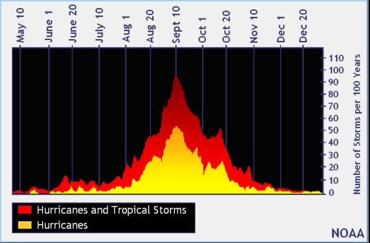
Hurricane season’s ultimate peak is Sept. 10 but the season goes through Nov. 30. Credit: NOAA
The peak of the season is Sept. 10, with the most activity happening between mid-August and mid-October, according to the Hurricane Center.
Tropical forecast over the next seven days
Excessive rainfall forecast
What’s out there?
Systems are currently being monitored by the National Hurricane Center.
Source: Naples Daily News


