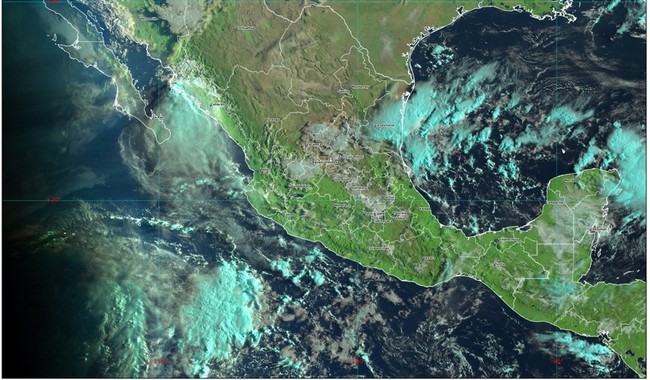
Off the coast of Quintana Roo, a low-pressure area with a 70% probability to form a tropical cyclone in 48 hours is being monitored. Waves of 2 to 3 m in height and conditions for waterspouts are expected on the coasts of Quintana Roo and northeastern Yucatán.
The weather forecast for this weekend is for heavy rains (from 75 to 150 millimeters [mm]) for Campeche, Chiapas, Nayarit, Quintana Roo and Yucatán; very strong (from 50 to 75 mm) in Colima, Guerrero, Hidalgo, Jalisco, Michoacán, Oaxaca, Puebla, San Luis Potosí, Tabasco, Tamaulipas and Veracruz; strong (from 25 to 50 mm) for Mexico City, the State of Mexico, Morelos, Tlaxcala and Sinaloa; showers (from 5 to 25 mm) in Chihuahua, Coahuila, Durango, Guanajuato, Nuevo León, Querétaro, Sonora and Zacatecas, and isolated rains (from 0.1 to 5 mm) for Baja California Sur and Aguascalientes.
The forecast rainfall would be accompanied by electrical discharges and conditions for hail fall. The heavy to intense rains could cause an increase in the levels of rivers and streams, overflows, landslides and floods, so it is recommended that the population follow the indications of Civil Protection in their locality.
Likewise, wind with gusts of 40 to 60 kilometers per hour (km/h) is forecast in Guerrero, Michoacán, Veracruz and the region of the Isthmus of Tehuantepec in Oaxaca, as well as with possible dust storms in Aguascalientes, Baja California, Chihuahua, Coahuila, Durango, Guanajuato, Jalisco, Nuevo León, San Luis Potosí, Sonora and Zacatecas.
There will be waves of 2 to 3 meters (m) high and conditions for the formation of waterspouts on the coasts of Quintana Roo and the northeast of Yucatán.
The rains and the wind will be caused by the presence of the Mexican monsoon, instability in the upper part of the atmosphere, a low-pressure channel over the southern Gulf of Mexico, the entry of moisture from both oceans and a low-pressure zone with Cyclonic potential off the coast of Quintana Roo.
At 06:00 hours, central Mexico time, the low pressure zone increased its probability to develop a tropical cyclone in 48 hours to 70 percent. It was located approximately 125 kilometers (km) east of Cancun, Quintana Roo, moving north.
In the Atlantic basin, tropical storm Franklin is being monitored, which is located approximately 515 km east-northeast of Grand Turk Island, without generating effects on Mexican territory.
Source: Mexico Gov.


